Precision Drone Services Across Northern California
High-resolution aerial imaging, mapping, inspections, and rescue support — serving Sonoma, Napa, Marin, Solano, Lake, and Mendocino Counties.
0
Counties
Sonoma, Napa, Marin, Solano, Lake & Mendocino
0
+ Flights
Completed safely by FAA-certified pilots
0
+ Clients
Construction, real estate, agriculture & utilities
0
+ Years
Trusted local experience in Northern California
Professional North Bay Area Drone Services
Sonoma County & Napa County
In Santa Rosa, Petaluma, Napa, and St. Helena, we support construction firms with progress monitoring, real estate professionals with property imagery, and vineyards with crop health analysis.
Marin County & Solano County
Lake County & Mendocino County
Drone Photography & Aerial Videography
Capture the full picture with high-resolution aerial imagery and stabilized 4K+ video. Our FAA-certified pilots provide professional drone photography and videography for real estate marketing in Santa Rosa and Napa, construction documentation in Petaluma and Fairfield, vineyard showcases in St. Helena and Sonoma Valley, and tourism promotion across Marin, Lake, and Mendocino counties.
From cinematic fly-throughs to detailed overhead property shots, our tailored flights deliver visuals that stand out on MLS listings, social media, and professional portfolios. Every project includes flexible flight paths, custom editing, and rapid turnaround—helping you elevate your story with precision and creativity.
Construction Progress Tracking
Keep your projects on schedule with recurring aerial documentation. Our drones provide high-resolution maps, 3D models, and site overviews that make it easy to track progress, compare timelines, and share updates with stakeholders.
Trusted by builders in Santa Rosa, Petaluma, Napa, St. Helena, Novato, San Rafael, Ukiah, Lakeport, and Fairfield, our FAA-certified team delivers audit-ready progress reports, annotated orthomosaics, and visual comparisons that integrate seamlessly with BIM and project management systems.
From residential developments in Sonoma County to commercial projects in Marin and Solano, we provide the data you need to identify issues early, improve communication, and reduce costly delays.
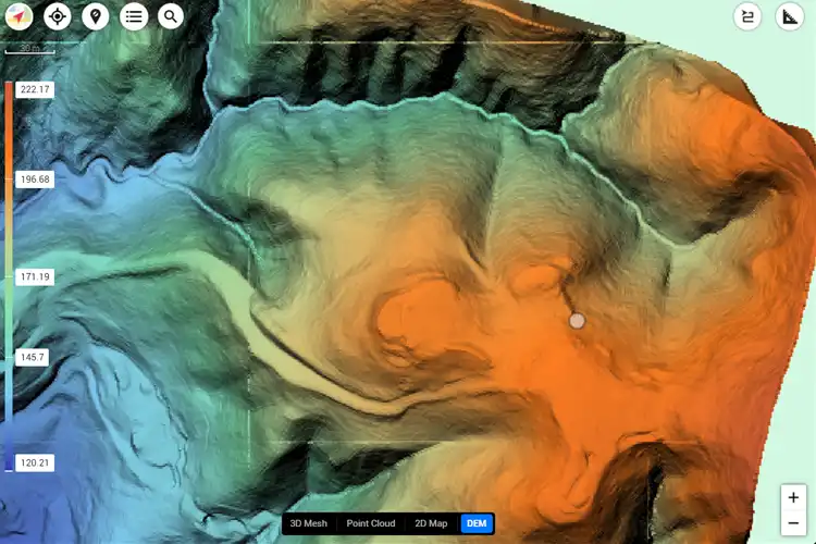
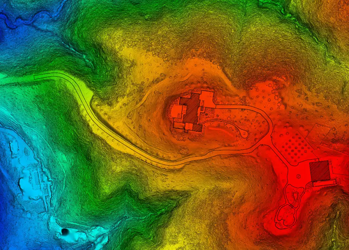
LiDAR Mapping & Photogrammetry Services
Transform landscapes into precise, actionable data. With advanced LiDAR sensors and photogrammetry techniques, we generate geo-referenced orthomosaics, 3D point clouds, and detailed topographic surveys with sub-centimeter accuracy.
Our expertise supports civil engineering in Santa Rosa and Napa, urban planning in Fairfield and Novato, forestry and land management in Ukiah and Lakeport, and vineyard mapping throughout St. Helena, Sonoma Valley, and Calistoga. From construction progress to agricultural analysis, our aerial mapping delivers the speed and accuracy that traditional ground surveys can’t match.

Facade Inspections (Aerial)
Explore Cutting-Edge Drone Solutions
Aerial Mapping & Surveying
Construction Progress Tracking
Volumetric Calculations
A true industry professional and an incredible UAV pilot.
Justin Kwong
Highly recommend!!!
Pablo Carballado
What Our Clients Are Saying About Cyclone Drone Services
OUR CLIENTS