Contact Cyclone Drone Services
Get in touch with Cyclone Drone Services today for expert aerial imaging, drone photography, and inspection services across Sonoma, Napa, Marin, Solano, Lake, and Mendocino counties.
Let’s Start a Project Together!
Frequently Asked Questions – Drone Services in Sonoma, Napa, Marin, Solano, Lake & Mendocino Counties
Have questions about our aerial drone photography, videography, LiDAR mapping, or thermal inspections? Explore our FAQ section for answers on drone roof scans, construction progress tracking, real estate imaging, and animal rescue support across Northern California. If you don’t see your question here, contact Cyclone Drone Services for expert guidance and custom solutions.
What makes Cyclone Drone Services’ aerial photography and inspections unique in Sonoma, Napa, Marin, Solano, Lake, and Mendocino counties?
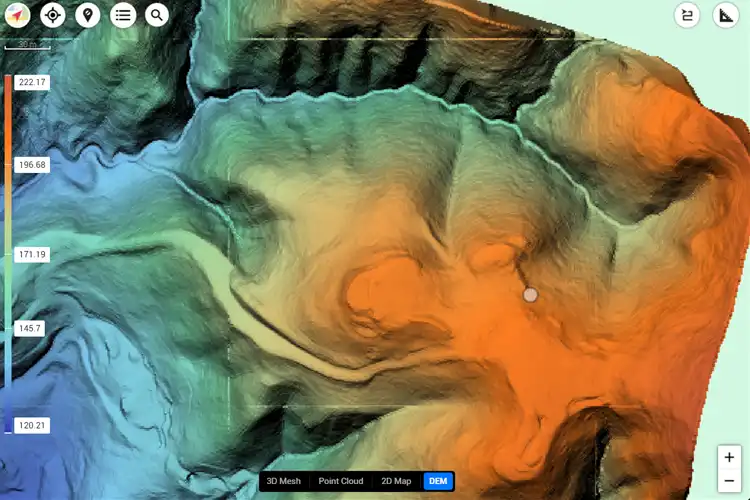
Our FAA-certified drone pilots use advanced imaging tools including LiDAR, thermal sensors, and 4K videography. We provide tailored solutions for construction monitoring, real estate, agriculture, and utilities across Northern California.
Can I book Cyclone Drone Services for a one-time project, or do you offer ongoing aerial monitoring packages?
We provide both single-project drone services such as roof inspections, real estate photography, or animal rescue support, as well as recurring monitoring packages for construction and agriculture in Sonoma, Napa, Marin, Solano, Lake, and Mendocino counties.
How do you ensure accuracy and consistency in your drone imaging and reporting?
We use industry-standard flight planning software, FLIR-certified thermal sensors, and photogrammetric processing to ensure accurate, repeatable, and consistent results across multiple flights and projects.
Do you customize your drone services for different industries like real estate, construction, and agriculture?
Yes. Our drone services are tailored to meet the unique needs of each sector—high-resolution imagery for real estate listings, volumetric analysis for construction sites, crop health monitoring for agriculture, and thermal scans for utilities and roof inspections.
What kind of reports and deliverables do you provide after a drone flight?
We deliver annotated maps, 3D models, thermal imaging reports, progress photos, and 4K videos. Our deliverables are integration-ready for BIM, GIS, and project management systems, helping clients make informed decisions quickly.