Drone Photogrammetry Mapping Services in Sonoma, Napa, Marin, Solano, Lake & Mendocino Counties
We provide FAA-certified drone photogrammetry solutions that deliver precise orthomosaics, DSMs, DTMs, and 3D point clouds. Serving clients across Sonoma, Napa Valley, Marin, Solano, Lake, and Mendocino Counties, we specialize in accurate aerial mapping for engineering, construction, agriculture, and urban planning projects.
Drone Photogrammetry & 3D Modeling
Our drone photogrammetry workflows utilize advanced aerial triangulation and image stitching algorithms to generate geo-accurate maps and models. Whether you need 2D orthomosaics for construction monitoring in Sonoma, 3D models for urban planning in Napa, or topographic surveys in Mendocino, we deliver data you can trust.
2D Orthomosaic Mapping
High-resolution, geo-referenced orthomosaic maps for construction sites, agriculture, and land development in Sonoma, Napa, Marin, and Solano Counties.
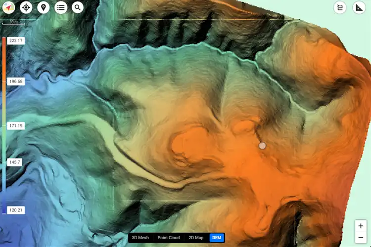
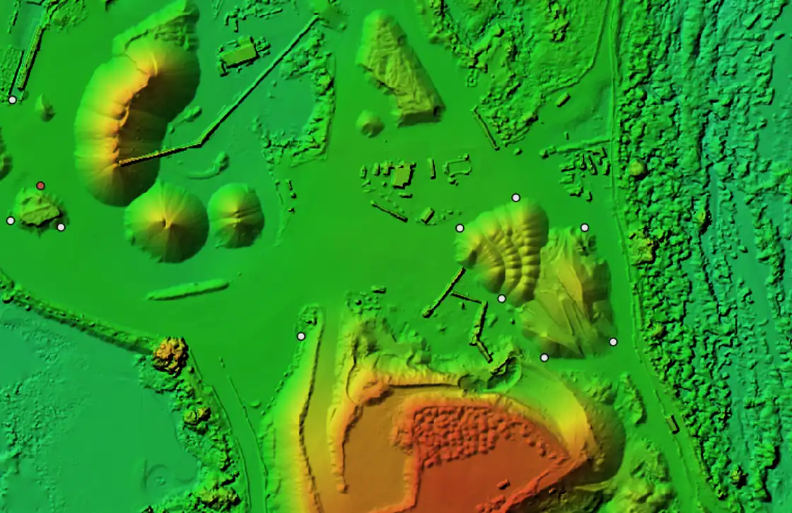
3D Modeling & Point Clouds
Accurate 3D models and point clouds for urban planning, mining, and infrastructure in Lake and Mendocino Counties.
Topographic Surveys
Generate DSMs and DTMs for engineering projects, grading plans, and watershed analysis across Northern California.
Construction Monitoring
Track progress with regular photogrammetry updates, ensuring accurate reporting and visualization for projects in Napa, Sonoma, and Marin Counties.
Why Choose Drone Photogrammetry?
Cyclone Drone Services delivers scalable photogrammetry solutions designed for precision, efficiency, and cost savings. From vineyards in Napa Valley to coastal mapping in Marin and infrastructure projects in Solano, our data is geo-referenced and built to industry standards.
Urban Planning
Accurate 3D models and mapping tools that support smart growth initiatives in cities across Sonoma and Napa Counties.
Agriculture & Vineyards
Monitor crops, vineyards, and farmland in Mendocino, Lake, and Napa using photogrammetry-based analysis.
Environmental Studies
Support watershed monitoring, forest management, and environmental restoration projects throughout Northern California.
Applications of Drone Photogrammetry
Our photogrammetry solutions serve diverse industries across Sonoma, Napa, Marin, Solano, Lake, and Mendocino Counties. From construction to agriculture and environmental management, Cyclone Drone Services ensures accuracy at scale.
1
Construction & Development
- Progress monitoring
- Earthwork volume calculations
- Infrastructure documentation
- Subdivision planning
2
Surveying & Mapping
- 2D orthomosaics
- 3D point clouds
- DSMs & DTMs
- Urban planning surveys
3
Agriculture & Land Management
- Vineyard health analysis (Napa & Sonoma)
- Crop monitoring (Lake & Mendocino)
- Forestry surveys
- Watershed studies
4
Environmental & Utilities
- Floodplain mapping
- Renewable energy site surveys
- Coastal erosion monitoring (Marin)
- Environmental impact assessments
Our Photogrammetry Workflow
Our photogrammetry process begins with tailored flight planning, followed by high-resolution aerial capture. Using advanced image stitching, we generate geo-referenced maps, models, and reports. Whether in Napa, Sonoma, Marin, Solano, Lake, or Mendocino, our workflow ensures precision results from start to finish.
A true industry professional and an incredible UAV pilot.
Cyclone Drone Services really delivers on exceptional aerial data and videography needs. If you need a beautiful perspective from the sky, you’ve found the right Drone Service Provider! You will not be disappointed!
Justin Kwong
Local Guide
Posted 2 weeks ago
This company not only has exceptional customer service but they are incredibly passionate and professional about their business.
Highly recommend!!!
Pablo Carballado
Verified Reviewer
Posted 6 months ago
What Our Clients Are Saying About Cyclone Drone Services
See why customers trust Cyclone Drone Services for professional UAV piloting, aerial videography, and data solutions. Here are real reviews from our clients.